AAWSAP DIRD, Detection and High-Resolution Tracking of Vehicles at Hypersonic Velocities, November 2010
DOW-UAP-D148 · page 28 of 46
Text
This text came with the file. It may have mistakes. When the text and the image disagree, the image is right.
UNCLASSIFIED/fFOR. QFFIEIA.L: Ulii Qt!! X
LIDAR. By attaching a rotating mirror to vary the direction of the laser beam, it is possible to
traverse the laser across surfaces to develop 3-D maps of objects using "imaging LIDAR." As
an example, during the DARPA challenge held in the Nevada desert in 2005, autonomous
automobiles used LIDAR to build a map of all objects in front of the vehicle and used it for
collision avoidance and navigation. LIDAR systems have also been used to obtain accurate
maps of the surface of mars from the Mars Orbiting Global Surveyer.
LIDAR systems for
meteorological studies are often mounted in aircraft and fired from the side of the fuselage to
obtain a two-dimensional horizontal map of the atmospheric conditions.
A measurement technique known as Laser Doppler Velocimetry (LDV) uses the Doppler shift
in the transmitted and reflected laser light to measure the velocity of the target and the
properties of the air along the axis of the laser beam.
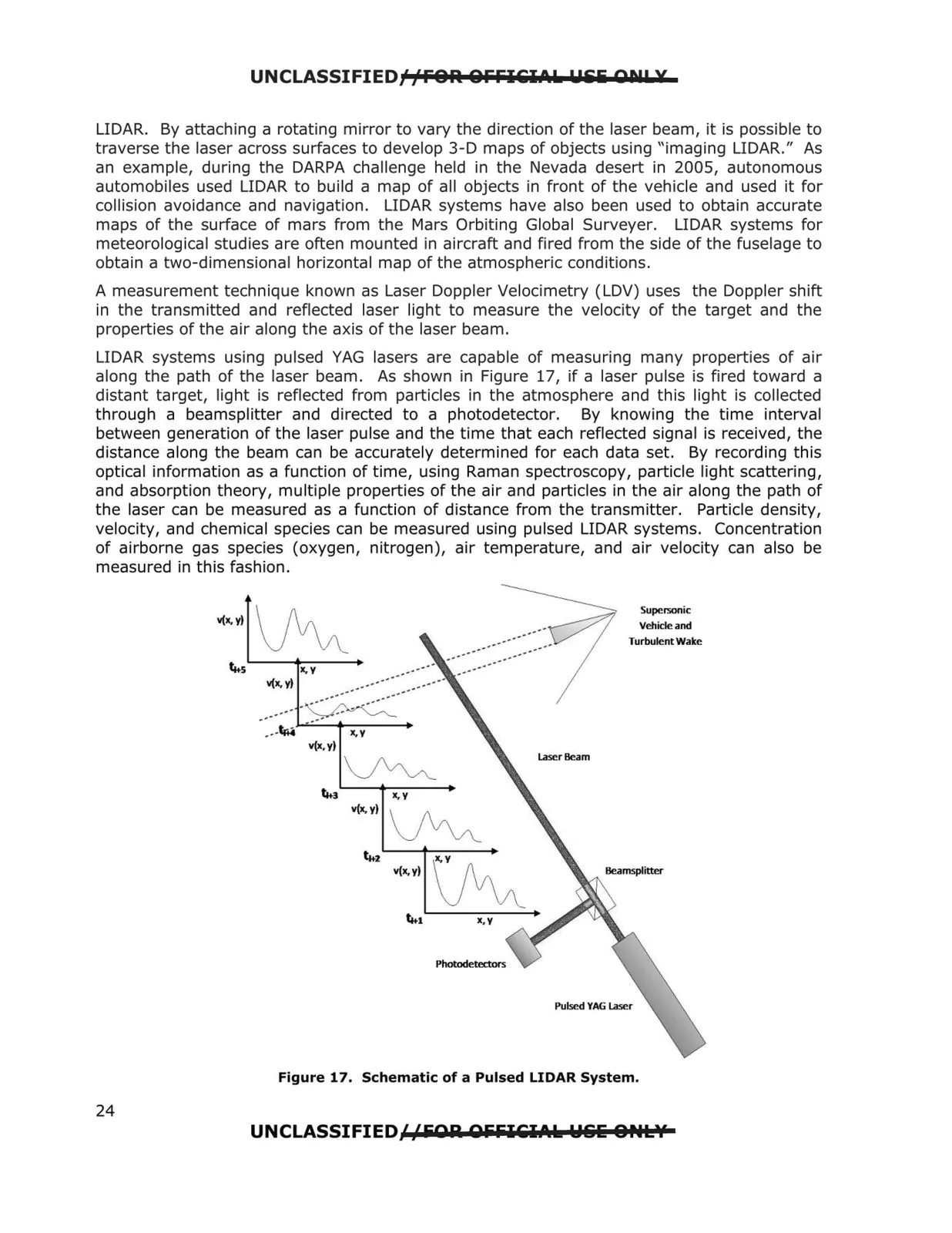
LIDAR systems using pulsed YAG lasers are capable of measuring many properties of air
along the path of the laser beam. As shown in Figure 17, if a laser pulse is fired toward a
distant target, light is reflected from particles in the atmosphere and this light is collected
through a beamsplitter and directed to a photodetector.
By knowing the time interval
between generation of the laser pulse and the time that each reflected signal is received, the
distance along the beam can be accurately determined for each data set. By recording this
optical information as a function of time, using Raman spectroscopy, particle light scattering,
and absorption theory, multiple properties of the air and particles in the air along the path of
the laser can be measured as a function of distance from the transmitter. Particle density,
velocity, and chemical species can be measured using pulsed LIDAR systems. Concentration
of airborne gas species (oxygen, nitrogen), air temperature, and air velocity can also be
measured in this fashion.
v(x, YI ~
v(x,y)
~
X,Y
v(x.y)
~
v(x,y)
Laser Beam
Supel50fliC
Vehicle and
Turbulent Wake
Figure 17. Schematic of a Pulsed LIDAR System.
UNCLASSIFIED//FQR QfifilEIA.k W&li O,.L\f
24